Pilsen has always been a neighborhood of immigrants. The Irish arrived in the 1840s to do the back breaking work of building canals, roads and railroad tracks. They were followed by waves of immigrants from Germany, Czechoslovakia, Poland, and Italy, among other places. The Czech population dominated, as thousands fled the Austrian Empire seeking political and religious freedom. A popular, nostalgic Czech Bohemian hangout, a restaurant named At the City of Plzeň, gave the neighborhood its name.
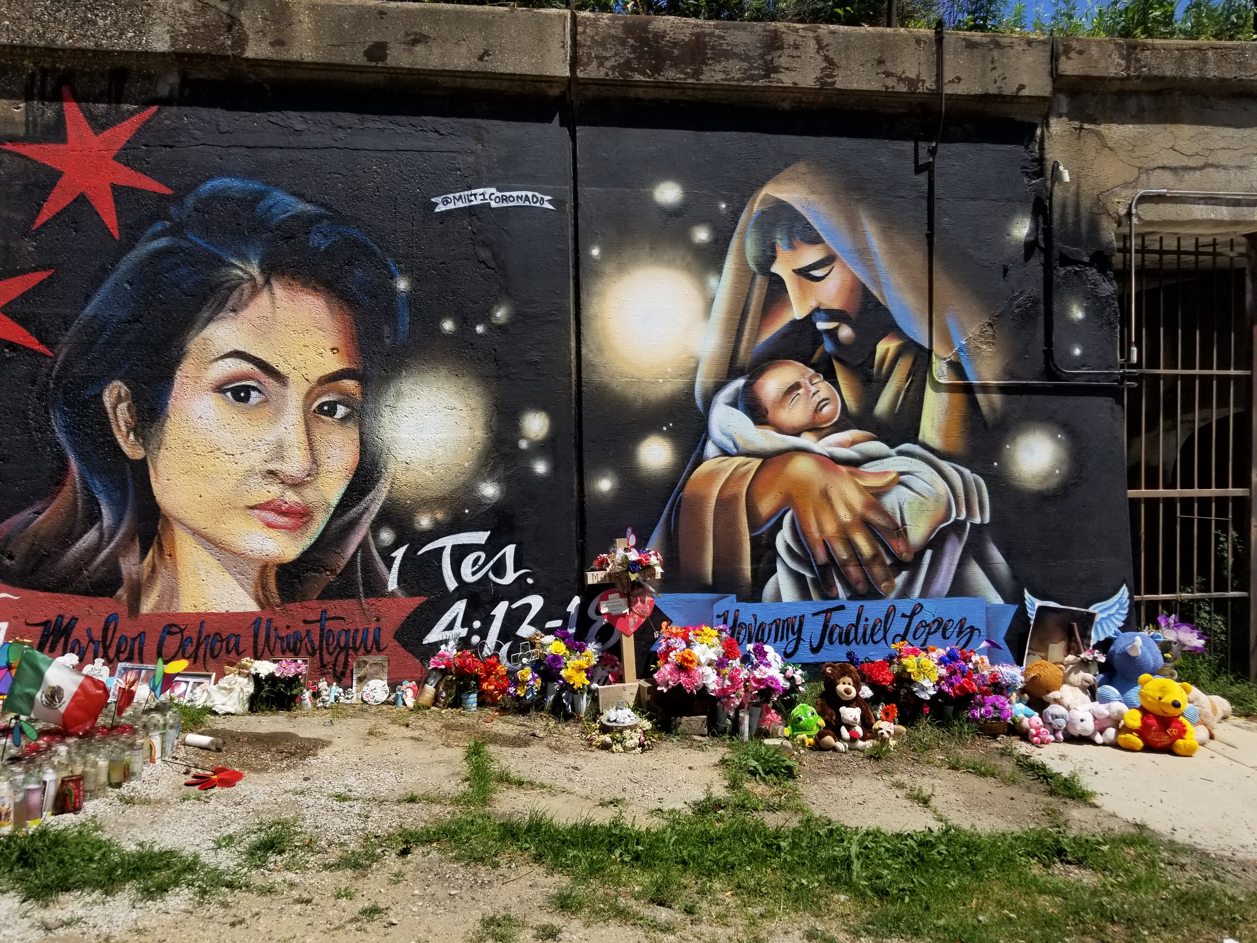
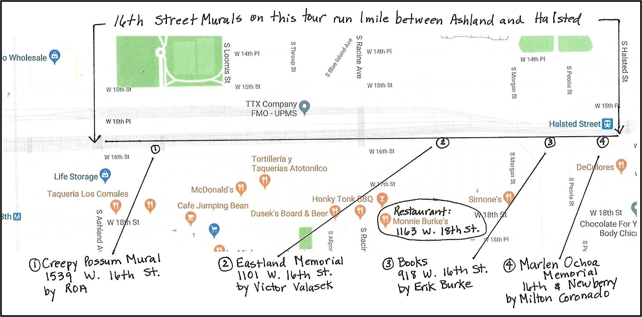
Pilsen’s current dominant immigrant culture is Mexican and this influence is what gives the area its charm. Colorful Murals are everywhere. Our highlight to tour before dinner is the wall of Murals along the railroad embankment between Halsted and Ashland called the 16th Street Murals.
This is a memorial to Marlen Ochoa-Lopez and her baby son who were brutally murdered earlier this year.
This is a one mile stretch to meander. You can drive, stop and look closer as different paintings catch your eye. It is easy to pull over and park along the side of the road as you drive down it. If you are really organized, you can Google “16th Street Murals Pilsen” or “Pilsen Murals” and find an abundance of articles and videos about the murals, their history and information about the artists. I included the location of some of our favorites on the map.
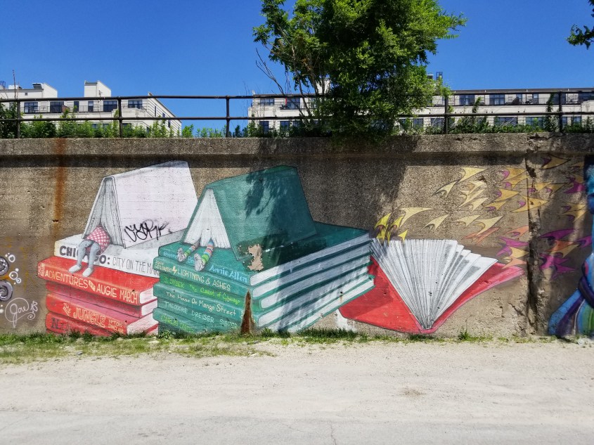
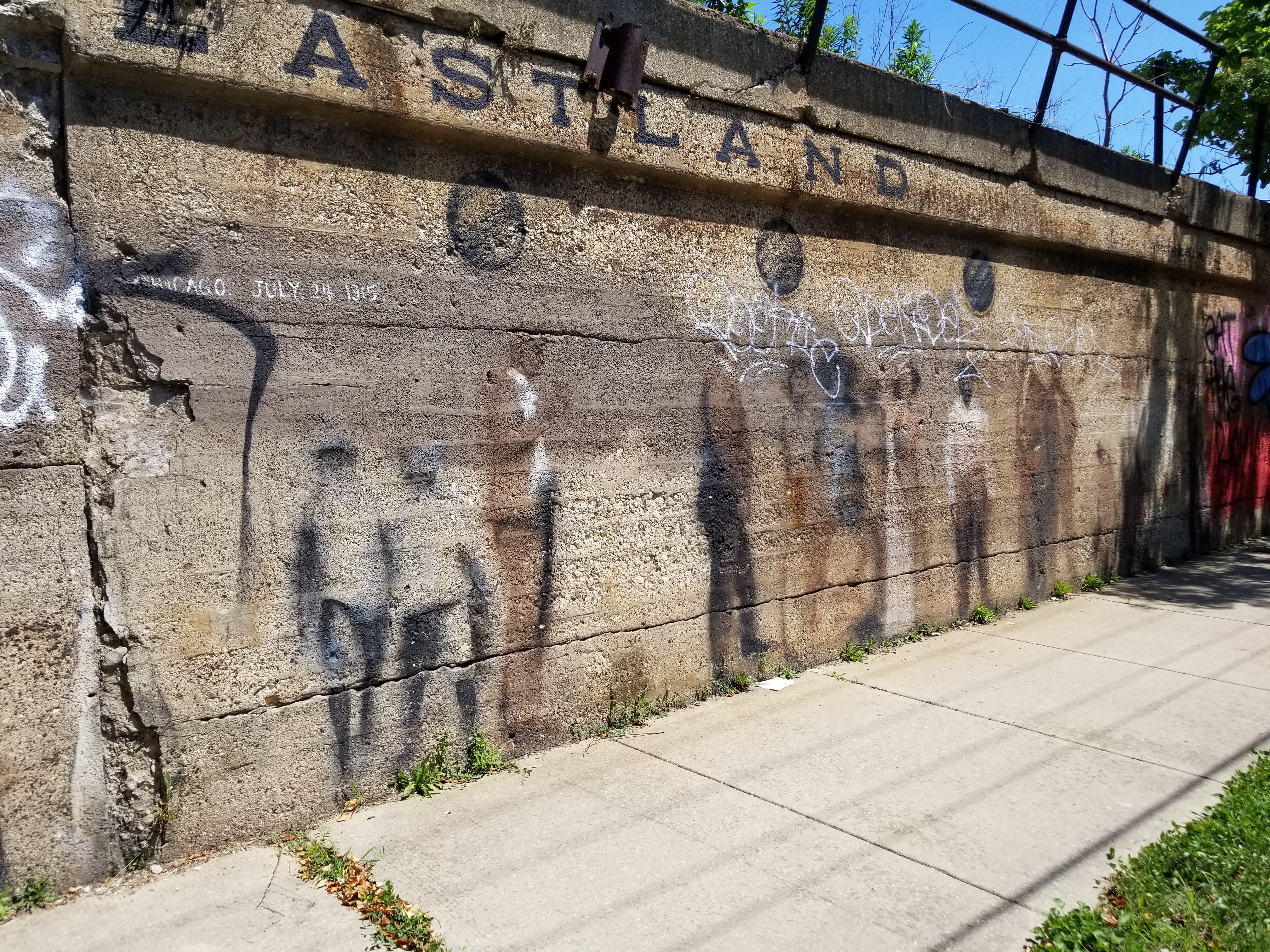
Some are whimsical. Love the feet hanging out of the books!These must be the ghosts of the Eastland Disaster, where 844 people died when a boat tipped over on the Chicago River in 1915.
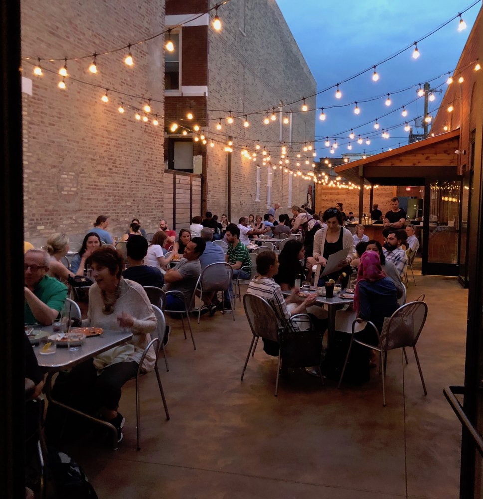
The murals and sights around the community reflect the culture of its Mexican residents, but our dinner choice is clearly a symbol of the encroaching gentrification in the neighborhood. We chose Monnie Burke’s (1163 W. 18th Street) for its large outdoor patio. We should mention the food is fabulous, always well prepared and lives up to its description on the website:
“Monnie Burke’s serves New American plates and inventive craft cocktails in the Pilsen neighborhood of Chicago. The elegant and spacious interior is accompanied by one of the largest patios in Chicago, which is privately tucked between buildings. The menu utilizes seasonal ingredients to create bold and unexpected flavors, and the cuisine is complemented by a thoughtfully curated and ever-rotating craft beer, wine and cocktail list.”
But when it’s warm in Chicago…. it’s all about the patio.
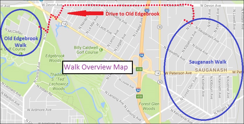
Length of Walk: The walk through Sauganash is 2.0 miles. You will then drive 1.5 miles to Old Edgebrook and walk about a mile there.
Where it is Located: Sauganash and Old Edgebrook are neighborhoods within the Community Area of Forest Glen. It is Walk #14 on the Walks Location Map.
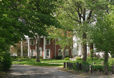
Home in Old Edgebrook
How we got there: We drove and parked where we wanted to start our walk in each neighborhood. Street parking is easy and plentiful. Public transportation options can be reviewed at: CTA Trip Planner
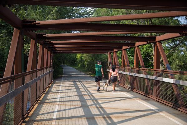
Sauganash Trail
Marge’s Comments: You will forget you are in the city of Chicago when you walk these neighborhoods! Upscale, pretty, historical and nestled in the woods, you will feel far from the grit of the city. The residential architecture in Sauganash seems more diverse than elsewhere in the city. Instead of the usual bungalow and four square, you will see some unique Art Deco and Art Moderne homes as well as various revival homes in the French, Colonial, Italian and Tudor style. If you feel miles away from the city in Sauganash, you might feel like you’ve escaped to the country in Old Edgebrook, which lies within the Cook County Forest Preserve of Edgebrook Woods.
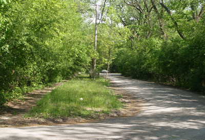
One of only two roads that lead into Old Edgebrook
Ed’s Comments: These two walks, so near each other, are a wonderful way to experience the contrast of different Chicago neighborhoods. Sauganash is a charming, suburban-like old neighborhood with interesting, well maintained homes and a historic parish church. Not much has changed in 50 years and, in a sense, time has stood still for the visitor.
Old Edgebrook is a two block village in the middle of the forest. You would expect a gingerbread house at any moment and we did see a deer on the side of a house during our walk. The overlook of the golf course and northwest branch of the Chicago river is charming. Great walk any time of the year. The two walks go together like tomatoes and mint. Tasty, but so different.
The land where Sauganash stands was inhabited by Native Americans in the early 19th Century. The name “Sauganash” comes from Billy Caldwell, the Potawatomi son of a Mohawk mother and British officer father. Given the name “Chief Sauganash,” meaning Englishman, Caldwell mediated treaties between the Native Americans and the United States.
As thanks for his diplomacy, in 1828 the government gave him the nearly two-and-one-half-square-mile area that is now occupied by Sauganash and Edgebrook. This 1,600-acre parcel of land stretched along both sides of the Chicago River—crucial for food, water and transportation—which accounts for the diagonal street pattern.
In 1912 a small portion of the Billy Caldwell Reserve, 260 acres, was purchased by one of the oldest and most respected real estate firms in Chicago, Koester and Zander, and named “Sauganash,” to denote the area’s history. While the first eight homes on Kostner Avenue between Peterson and Rogers Avenues were completed by 1924, two hundred homes were completed by 1930.
Sauganash is a blend of several distinctive architecture styles, ranging from bungalows and Cape Cod cottages to the palatial French and Classical Revival designs, as well as Art Deco and Art Moderne. The principal architectural style is Tudor Revival.
Koester and Zander laid the foundation for Sauganash’s distinctive green space by planting more than 20 varieties of trees, including oak, sycamore and mountain ash, lending to the lush character of the community. By the 1930s, census records show the area catered to upper middle-class families.
(Info from the Sauganash Chamber of Commerce website)
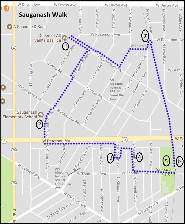
Part of Sauganash is a National Historic District and that is where our walk takes us today. As original Art Deco and Art Moderne homes are so rare to see, we’ve selected this style to show you on the walk. There are many architectural styles represented in the district and they are itemized in the Sauganash National Historic District Info . You may want to use it as a guide as to design your own walk through the district to architectural styles you are most interested in.
Park near Queen of All Saints to start the walk
Queen of All Saints Basilica 6280 N. Sauganash Ave.
An important Sauganash landmark is Queen of All Saints Basilica. The church, designed in a Neo-Gothic style by Meyer and Cook, was completed in 1960. The magnificent, cathedral-like church was raised to the dignity of a basilica by Pope John XXIII on March 26, 1962. The large window over the choir loft features eight different shrines of the Virgin Mary, each particular to a certain country or culture representing the different ethnic groups living in Sauganash. (from The Sauganash Chamber of Commerce website)
Sauganash Elementary School 6040 N. Kilpatrick Ave.
This school was built by the Works Public Administration (WPA) in 1936. Designed by John C. Christensen, the long-time architect for Chicago Public Schools, this two story brick and terra cotta school is a good example of New Deal-era Art Deco public architecture. Situated on 2.5 acres, the Sauganash Elementary School and its grounds provide recreational and green space for residents. (From the National Register of Historic Places Registration Form)
Art Deco Residence 5928 N. Kilbourn
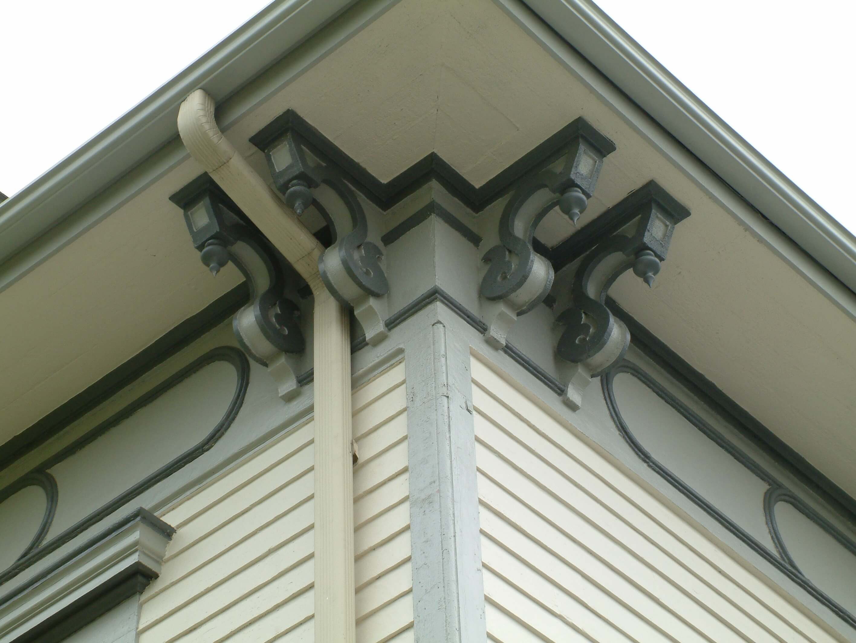
Described by the Chicago Daily Tribune as “a residence said to reach the zenith of modernism,” the house here was perhaps one of the earliest Art Deco small homes in the nation. Built by Herman Voss, the house features many typical Art Deco elements. Vertical lines are emphasized all along the front elevation, both in the long rectangular windows, and in the ornamental pilasters that frame two round windows. Decorative elements, such as the detailing at the corners of the wall below the roofline, add to the Art Deco feel of the house. (From the National Register of Historic Places Registration Form)
Art Moderne Residence 5915 N. Kenneth
Inspired by streamlined industrial design, the Art Moderne style developed following Art Deco in the 1930s. Rather than building upon elements of the past as Art Deco had, Art Moderne was an attempt to create a glimpse into an exciting future during the Great Depression. The style is characterized by horizontal lines and rounded corners designed to simulate a feeling of movement. Architects also borrowed many elements directly from the transportation industry, such as chrome and circular windows. Because it was based on already familiar designs, Art Moderne was more accepted as a residential style. In addition, Art Modern lent itself well to remodeling projects, allowing budget conscious consumers to update their homes in the latest style.
The house here on Kenneth provides an excellent example of the Art Moderne design. The house is constructed of brick, with accent bricks set to create horizontal lines that appear to trail off after the windows. Round porthole-style windows are placed in the front door and entryway. A rounded wall of glass bricks at the south end of the house is a unique feature, reinforcing the streamlined appearance of the house. (From the National Register of Historic Places Registration Form)
Sauganash Park 5861 N. Kostner Ave.
The single story English style fieldhouse dates back to 1934. In the mid-1970s, a large gymnasium was added to the fieldhouse. Because the addition detracts from the design, materials and feeling of the original Tudor-style field house, the fieldhouse is a non-contributing resource in the Sauganash Historic District.
Sauganash Trail Park Access the trail east of the park
The Sauganash Trail officially opened June 21, 2008. It’s one mile long, running from Bryn Mawr to Devon near Kostner. It’s a wonderful little path that is used regularly by locals. Community residents can access the path at Bryn Mawr to pedal downtown, take a leisurely stroll or power walk, walk their dog, or take jog in the neighborhood.
Enter the trail at the park, enjoy a brief half mile stroll, and exit at the first access point you see.
You will emerge onto W. Thome Avenue.
Follow the map or wander around more of these lovely streets to return to your car.
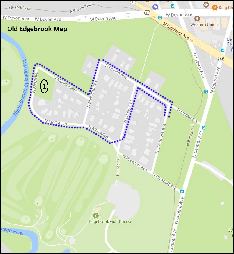
After returning to your car, drive over to Old Edgebrook
Old Edgebrook Walk
Planned originally in 1894 as a neighborhood for executives of the Milwaukee Road Railway Co., Old Edgebrook is rich in architecture, history and rustic charm. There are just 48 homes in this small community with winding, heavily forested streets. The architecture represents almost every style popular with middle and upper middle class families in the 1890s through the 1940s.
Wildlife abounds as the neighborhood is surrounded by the Edgebrook Golf Course, Cook County Forest Preserve and the Chicago River. The two roads leading in and out are heavily wooded, adding to the secluded feel of the area.
This neighborhood became a Chicago Historic District in 1988.
The route plotted through the neighborhood is entirely random, so meander as you wish to the only item on the walk that I have listed.
Mary Burkemeier Quinn Park of Trees (aka Quinn Park) 6239 N. McClellan Ave.
This is one of the smallest Chicago Park District Parks. When Edward Quinn died in 1980, he left their property to the Chicago Park District for a park to be named after his wife. Under the terms of the bequest, he instructed that his house be demolished and a minimum of 21 trees be planted on the site. In 1988, the wooded park became part of the City of Chicago’s Old Edgebrook Historic Landmark District.
Where it is located: East Humboldt Park is actually a neighborhood on the west side of the West Town Community Area. It includes Humboldt Park and the famous Puerto Rican “Paseo Boricua”, which are the focuses of this walk. It is Walk #13 on the Walks Location Map.
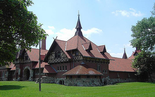
Humboldt Park Receptory Building and Stable, home to the National Museum of Puerto Rican Arts and Culture
How we got there: We drove and parked inside Humboldt Park at the start of the walk. We entered on N. Albany off North Avenue just east of the Armory and found a spot right away. You can check out your public transportation options with the CTA Trip Planner.
from Chuckman’s Photos
Marge’s Comments: It’s been a couple of years since we took this walk, but what I remember most is feeling wistful that I had never seen the park at the peak of its glory, probably in the mid 1900s. Its bones are magnificent and the restoration of the Stables is a must see. The lagoons, gardens and fieldhouse are mere shadows of their former selves but still impressive. Emerging from the park onto the Puerto Rican Paseo Boricua is a lively change of pace with vibrant street life, colorful murals and ethnic eateries.
Puerto Rican Flag on Paseo Boricua (Division St.)
Ed’s Comments: This walk is more of a park walk than a neighborhood walk as most of the mileage is within Humboldt Park. Nevertheless, you couldn’t find a more delightful inner-city park just a short distance from all the interesting neighborhoods on the near west side of town. The ponds, pavilions, trails, and formal gardens are a delight most months of the year. Don’t miss the Puerto Rican Heritage Museum in the old horse stables south of Division Street.
This neighborhood has followed the pattern of so many Chicago neighborhoods. It has seen successive waves of immigrants, lured by rail access and factory work. Germans, Scandinavians, Poles, Jews and Italians lived here around the turn of the 20th century. As the century progressed, they migrated elsewhere. The area deteriorated and fell victim to gangs and decline.
The latter half of the century saw the area as a Latino “port of entry” neighborhood. Puerto Ricans and Mexicans comprised about 62% of the population by 1990. There were periods of riots and unrest among the Puerto Rican community because of police treatment of its residents. In 1995, Division Street found new life when city officials and Latino leaders decided on a public art project to recognize the neighborhood and the residents’ roots. They christened it “Paseo Boricua” and installed two metal Puerto Rican flags—each weighing 45 tons, measuring 59 feet (18 m) vertically and stretching across the street—at each end of the strip.
This is considered the flagship of Puerto Rican enclaves in the United States and is the political and cultural capital of the Puerto Rican community in the Midwest. It is home to a cultural center, colorful murals, vibrant street life and music, and a yearly festival and parade.
The neighborhood is changing once again. Gentrification has brought higher real estate values and taxes and poorer residents are getting edged out. Latino makeup has fallen to 47% and is declining.
Humboldt Park (the Park) is on the National Register of Historic Places and the Boathouse and Stables are designated Chicago landmarks.
History of Humboldt Park, the Park: (from Wikipedia) William Le Baron Jenney began developing the park in the 1870s, molding a flat prairie landscape into a “pleasure ground” with horse trails and a pair of lagoons. The park opened to the public in 1877, but landscape architects such as Jens Jensen made significant additions to the park over the next few decades. Between 1905 and 1920, Jensen connected the two lagoons with a river, planted a rose garden, and built a fieldhouse, boathouse, and music pavilion. There is an audio tour on the Chicago Park District website of the park that gives more history and information. (The walk is also available at Tour Budy.)
At the request of the largely German born population at the time, the park was named after Baron Freidrich Heinrich Alexander Von Humboldt (1759-1859), the famous German scientist and explorer, though Humboldt had only visited the U.S. once and had never been to Chicago.
1.) Humboldt Park Fieldhouse 1400 N. Sacramento
In 1928, the West Park Commission constructed a fieldhouse in Humboldt Park. The structure was designed by architects Michaelsen and Rognstad, who were also responsible for other notable buildings including the Garfield Park Gold Dome Building, the Douglas and LaFolette Park Fieldhouses, and the On Leong Chinese Merchant’s Association Building in Chinatown.
2.) Boathouse 1301 N. Sacramento
Jens Jensen commissioned Schmidt, Garden, and Martin to design an impressive boat house and refectory building (1907) which still stands at one end of the historic music court. There is a café here which has outdoor seating and pretty views of the park.
3.) Bison Bronzes at the Formal Garden
The two bison at the Formal Garden were sculpted by Edward Kemeys who also created the lions in front of the Art Institute.
4.) Formal Garden
Jens Jensen created this garden in 1908. It once featured semi-circular beds of roses and other perennials, as well as an upper terrace with wooden and concrete pergolas, according to the Jensen Formal Garden Restoration Project website.
“He called it a ‘community garden’ explaining that it was created for ‘those who have no other gardens except their window sills,'” the website reads.
Over the years, the garden has deteriorated: the concrete walls and pergolas are cracking, the wood is rotting, some flowers beds have been sodded over and very few flowers remain, according to the website.
DNA Info reported on May 2, 2017 that the prominent Dutch designer behind the award-winning Lurie Garden in Millennium Park has been tapped to revitalize the garden. Plans include repairing the crumbling infrastructure and revitalizing the design features in keeping with Jensen’s famous Prairie style.
5.) Humboldt Park Receptory Building and Stable 3015 W. Division
This beautifully restored building houses the only year round museum dedicated to Puerto Rican arts and culture, the National Museum of Puerto Rican Arts and Culture. It has received 23 million dollars in renovations over the last several years. The Chicago Landmark Commission report describes the building’s appearance as “old German style of country house architecture” which looks vividly picturesque within the greenery of Humboldt Park. It was built in 1895 to house horses, wagons and landscaping tools.
It was designed by Frommann and Jebsen and also served as the office of the Humboldt Park Superintendent, Jens Jensen, whose office was in the turret. It is the oldest surviving building in Humboldt Park.
6.) Paseo Boricua Gateway Flags, 1995 One flag at Western and Division and one flag at California and Division
Each flag weighs 45 tons, measures 56’ high, and forms a 59’ arch from one side of the street to the other. They are made out of steel and steel pipeline welded together. The flags were made out of steel to honor the first wave of Puerto Rican immigrants who established themselves in Chicago and the Midwest to work for its steel industry in the mid-1940s. The second wave of Puerto Ricans came specifically to work on steel pipelines, the material the flags are made out of. These flags act as the gateway to Paseo Boricua, the portion of Division Street between these flags.
7.)Co-Op Image Graffiti Mural, 2011 Co-Op Image 2750 West Division St.
This graffiti style mural reflects the vitality of life on Division Street.The mural confirms that graffiti can be an art form and not just vandalism. The graffiti mural was legally sanctioned by an auto-mechanic shop that gave the organization permission to paint. The image in the center is from a photograph taken on April 16, 1936. Albizu Campos is rallying a crowd to become a force for independence.
8.) Born of Fire, 2006 Martin Soto 2700 West Division St.
This mural is a complicated narrative about the Puerto Rican community in Chicago. It contains images about education, culture, sports, gang violence, and Puerto Rican historical figures. The mural reflects community, social, and political concerns as well as neighborhood history and achievements with specific reference to the 1996 Division Street Riots and the Three Kings Festival. After the Riots, the community became more politically active and vibrant. Puerto Rico’s national flower, the maga, or hibiscus flower is depicted.
9.) La Casita de Don Pedro, 1998 archi-treasures, Dr. Pedro Albizu Campos High School, Puerto Rican Cultural Center of Chicago 2625 West Division St. •
This is a park dedicated to Humboldt Park’s Puerto Rican community designed to look like the Puerto Rican flag from above. Three red tiled stripes lead to the base of the statue, which is shaped like a star. “La casita” or “little house,” is a replica of a 1940s typical rural house in Puerto Rico with a zinc roof and a porch. The statue of Don Pedro Albizu Campos located in the center of the park was originally intended to be installed in Humboldt Park but was rejected by the Chicago Park District because Albizu Campos was thought to be too controversial. The park hosts bomba and plena dance and drum classes, political rallies, concerts, art exhibits, and other events. La Casita de Don Pedro was one of archi-treasures’ pilot projects completed in 1998.
10.) Honor Boricua, 1992 Hector Duarte 1318 North Rockwell St.
The mural honors the Puerto Rican heritage of many people in Humboldt Park. The flag flying across the sea from Old San Juan, Puerto Rico to Chicago and back represents the ongoing exchange of culture, resources, people, and ideas between the communities. The mural illustrates transnational and multicultural messages. The artist interviewed community members about their stories and used their ideas to develop the theme for the mural. Borinquen is the original Taíno Indian name for the Island of Puerto Rico.
11.) Breaking the Chains, 1971 John Pitman Weber 1500 North Rockwell St.
The mural is about community struggles. There are hands breaking the chains of poverty, racism, and war and holding up children carrying roses in a bright light that symbolizes a bright future for the next generation. The woman crying from the burning window is a reference to the arsons that plagued the community in the early 1970’s when landlords began burning buildings to collect the insurance on them.
If you want to see more murals, follow the aqua dotted line on the map and see more murals at stops A through F.
A.) La Crucifixion de Don Pedro Albizu Campos, 1971 Mario Galan, Jose Bermudez, Hector Rosario 2425 West North Ave.
Don Pedro Albizu Campos, the leader of the Puerto Rican Nationalist Party, is depicted crucified in the center alongside two other Nationalists of the 1950s. Portraits of six independence and abolitionist leaders of the 19th century are lined across the top. The flag in the background is called the La Bandera de Lares. It represents Puerto Rico’s first declaration of independence from Spain on September 23, 1868. This armed uprising is known as El Grito de Lares. It took nine years to save this mural from destruction. A new condominium was planned and if built, would have blocked off the mural. Community members concerned about gentrification of the neighborhood as well as saving the oldest Puerto Rican mural in Chicago went into action and saved it.
B.) I Will… The People United Cannot Be Defeated, 2004 Northeastern Illinois University Students 1300 North Western Ave.
The mural is sending a message that encourages people to vote. It depicts the activist figures Mother Jones, Fred Hampton, Eugene Debs, and Lucy Parsons. The mural reflects the mass mobilization of people to exercise their right to vote and to become active leaders toward positive social change. The title of the mural comes from a chant first heard at a Chilean protest.
D.)79th, 2009 John Vergara 2460 West Division St.
This mural depicts the recently designed Paseo Boricua flag that recognizes Humboldt Park as the heart of the City’s Puerto Rican community. The symbolism in the Coat of Arms connects Puerto Rico and its culture to the City of Chicago. Paseo Boricua is the first location outside the Commonwealth of Puerto Rico to be granted the right to fly an official Municipal Flag of Puerto Rico. The reason this mural is titled “79th” is that there are 78 municipalities in Puerto Rico and Paseo Boricua has the honor of being named the 79th.
E.) Sea of Flags, 2004 Gamaliel Ramirez with assistance from Star Padilla, Moncho, Luis Ortiz, Melissa Cintron, and community members 2500 West Division St.
The mural depicts a cultural/music event called Fiesta Boricua (De Bandera a Bandera). The Festival attracts over 250,000 people every year and is held in September. Visitors can hear salsa, reggaeton, bomba, plena, and merengue music pulsing in the streets. The mural depicts some famous people including National Puerto Rican icon Lolita Lebrón, Pedro Pietri, and Don Pedro Albizu Campos, the leader of the Puerto Rican Independence Movement who is depicted as a bronze statue on the left of the image. The abundance of Puerto Rican flags is an intentional comment by the artists. From 1898 to 1952, when Puerto Rico became annexed by the United States, it was considered a felony to display the Puerto Rican flag in public; the only flag permitted to be flown on the island was the United States flag.
F.) Escuelita Tropical, 2005 Eren Star Padilla 2516 West Division St. This is one of the few murals in the area created by a female artist. Symbols on the mural refer to Taíno petroglyphs and pictographs found in the Caribbean as well as Aztec symbols from Mexico. The symbols are Pre-Columbian and speak to the cultural identity of the Puerto Rican and Mexican children of Viva Child + Family, the child development center that owns the building where the mural is located.
Drive By Add On:
Some may remember the terrible school fire at Our Lady of Angels on December 1, 1958. Those of us alive at the time will never forget the tragic images of the fire that killed 92 children and 3 nuns. The replacement school closed and is now leased to a charter school, but there is a memorial on site at 3808 W. Iowa St., a close drive from this walk.
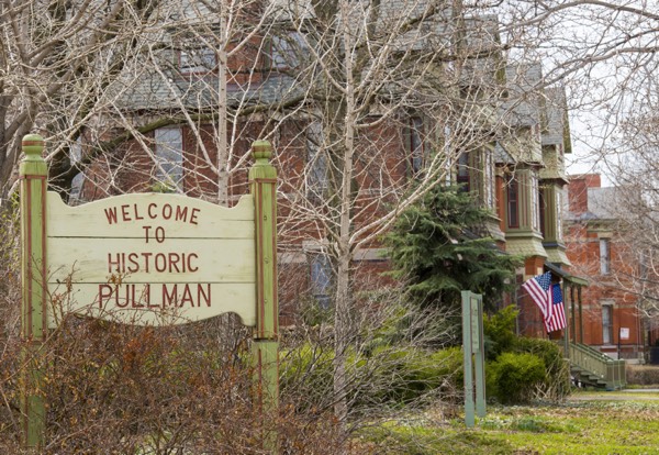
Where it is located: This walk takes you through the heart of the Pullman historic district in the community area of Pullman. It is Walk #12 on the Walks Location Map.
How we got there: We drove and parked at the Visitor Center. There is also street parking in the neighborhood. The Visitor Center provides detailed options for travel via car, bus and train.
Marge’s Comments: This was one of the first neighborhood walks I took after moving to the city in 2005. I was fascinated by the history of Pullman and knew that much of the “town” exists intact from when it was built in 1880 – 1884. Walking among the well preserved row homes once occupied by the workers of the Pullman factory helps you envision what life in Chicago may have been like over 100 years ago. The Visitor Center is a must see and greatly enhances your experience. The factory is a burned out hulk of a building and other sites are in shambles, but the future looks hopeful. The area has been gentrifying since the late 1900s, the district was declared a National Monument in 2015 and the commitment to restoration among community groups gives hope that the area will one day be restored fully.
Ed’s Comments:
The Pullman neighborhood is a spectacle: one part ruins and one part rising Phoenix. The ruins of the manufacturing complex that was absorbed by Chicago over a century ago is a humble reminder of man’s fate. In the adjoining neighborhood, once owned by the company, urban frontiersmen have made a delightful and safe haven for themselves. Down 111th Street and across I-94 the magnificent Harbourside Gold Course offers 36 holes, each with a breathtaking view of Chicago in the distance.
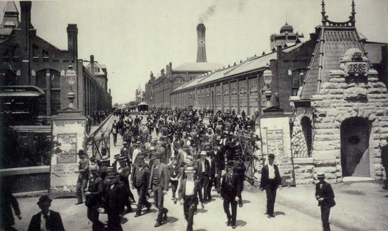
Pullman Workers
Before we get started:
This walk is very limited in that it takes place in the very tight area around the visitor center. If you are inclined to wander beyond it, please ask at the visitor center where to go, what to see and what is safe. They are very knowledgeable about the area and are very helpful.
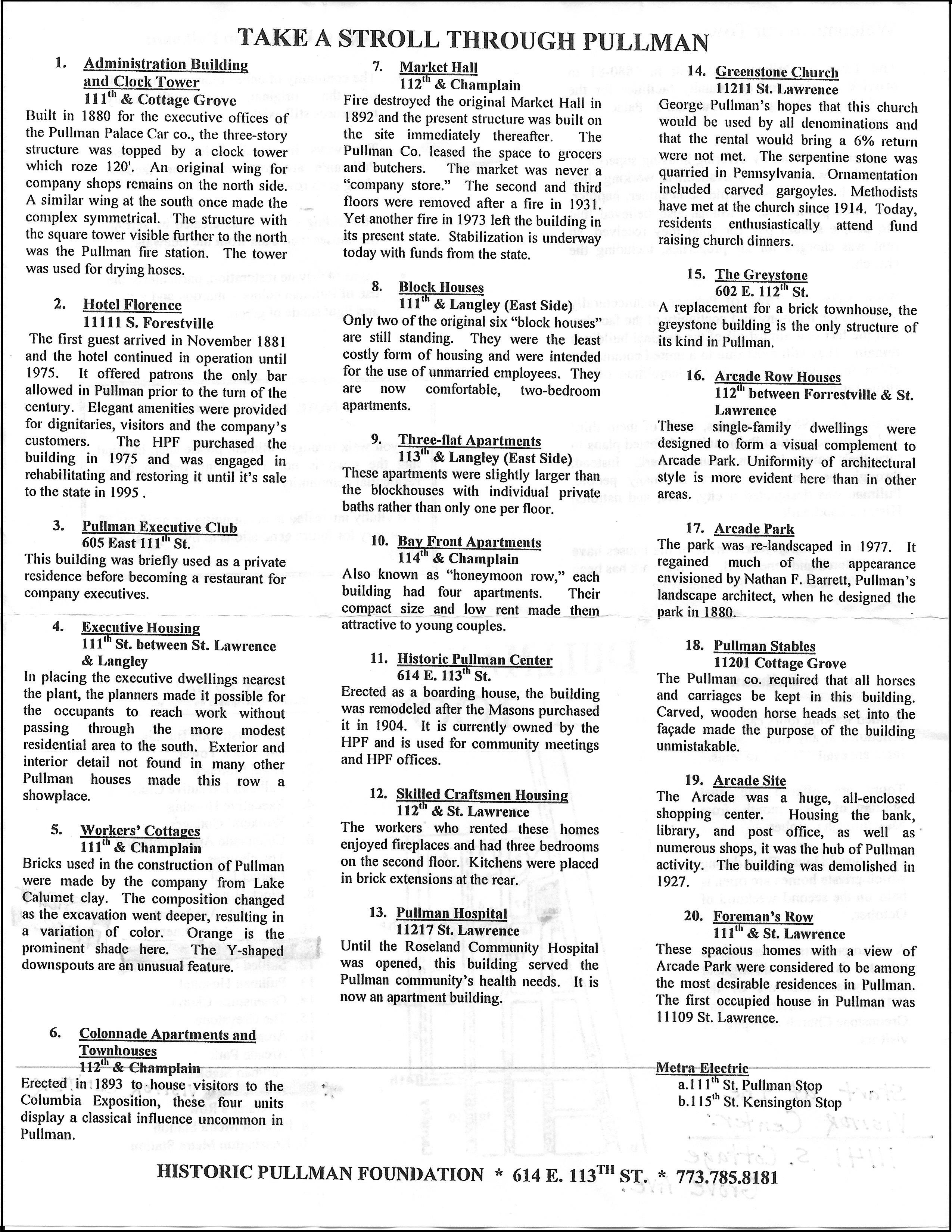
There are guided walking tours of Pullman on the first Sunday of every month from May to October. In addition, there is an Annual Historic Pullman House Tour weekend, where homes and sites in Pullman are open to the public. This is fabulous and gives you a chance to see inside some beautifully restored houses as well as the Florence Hotel and other historical sites. Highly recommended! However, if neither of those options fit with your schedule, you will still enjoy going to the Historic Pullman Foundation Visitor Center, browsing their exhibits and taking the self-guided walking tour with the map they provide. This map is reproduced here and makes up our walk for Pullman.
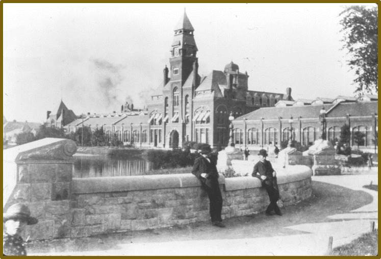
This walk covers only the Pullman Historic District, also known as the Pullman National Monument. It was the first model, planned industrial community in the United States. The district is significant for its historical origins in the Pullman Company, one of the most famous company towns in the United States, and scene of the violent 1894 Pullman strike.
Historic Pullman was built in the 1880s by George Pullman as workers’ housing for employees of his eponymous railroad car company, the Pullman Palace Car Company. He established behavioral standards that workers had to meet to live in the area and charged them rent.
Pullman’s architect, Solon Spencer Beman, was said to be extremely proud that he had met all the workers’ needs within the neighborhood he designed. The distinctive row houses were comfortable by the standards of the day and contained such amenities as indoor plumbing, gas and sewers.
During the depression that followed the Panic of 1893, demand for Pullman cars slackened. Despite cutbacks and wage reductions at the factory, the Company did not reduce rents for workers who lived in Pullman. Workers initiated the Pullman Strike in 1894 and it lasted 2 months, eventually leading to intervention by the U.S. Government and military.
After George Pullman died in 1897, the town was annexed by the city of Chicago and the city sold the houses to their occupants. Deindustrialization and migration to the suburbs led the area to fall into decline and a proposal to demolish the area to create new industrial development was defeated by the efforts of its residents.
Over the years local organizations and foundations have fought and won for recognition of Pullman as a Historic District and all the protections that brings.
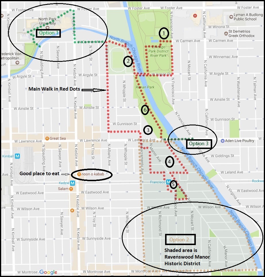
Length of Walk: The main walk is 2.4 miles. I’ve listed 3 optional excursions off the main walk. They include an extended walk in Ravenswood Manor, a trip to North Park University and a visit to the Cambodian Association.
Where it is located: This walk will take you to the east side of Albany Park Community Area. It is Walk #11 on the Walks Location Map.
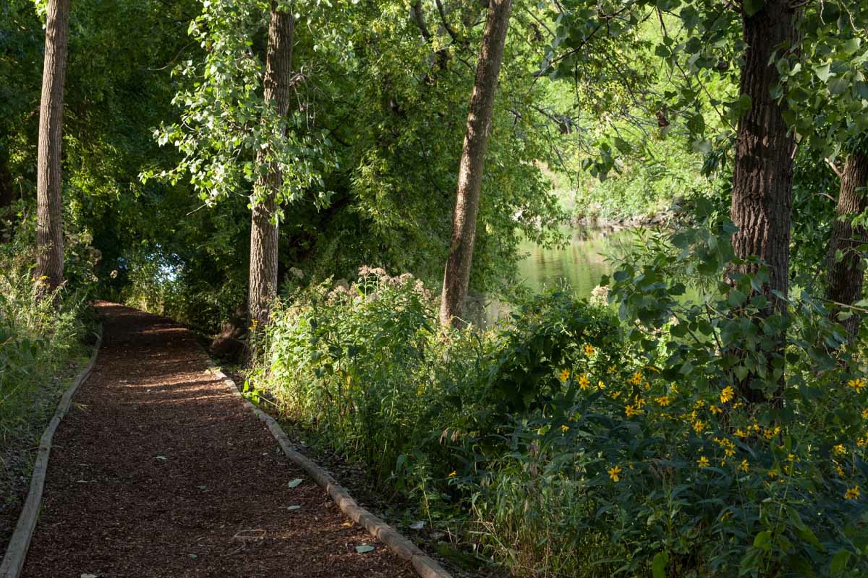
Ronan Park Path along the River
How we got there: We drove and parked on N. Francisco in front of the River Park Fieldhouse. Parking can be tight in this neighborhood. The Brown Line is a great option for getting here. Take it to the Francisco station (which is part of this walk) and start the walk at Stop #5 and make the loop. You can check out other public transportation options with the CTA Trip Planner.
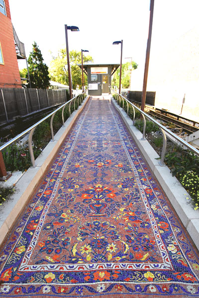
Carpet Mosaic at the Francisco Brown Line Station
Marge’s Comments: After walking this community, I wondered why it had taken me so long to discover it. The nature areas and parks, the charming historic district of Ravenswood Manor and the diversity of nationalities here make this walk a visual and cultural delight. If your exposure to this neighborhood has been using Lawrence Avenue as a thoroughfare to someplace else, stop, park the car and start exploring. You are in for a wonderful surprise.
Ed’s Comments: This is an easy walk and easy to get to but filled with so much local neighborhood interest. Although the bucolic north branch of the river is the spine of this area, the blocks are filled with newly arrived immigrants and stately old homes and bungalows. Try going and coming on the CTA Brown Line and feel what it is like to travel and live in this peaceful enclave.
This walk takes you to the very eastern part of Albany Park and even spills slightly over the border into North Park and Ravenswood. The western part of Albany Park is home to North Mayfair, another historic district, and will be the focus of another walk.
East Albany Park and Ravenswood Manor
German and Swedish immigrants initially settled the Albany Park area. After 1912, the area became home to a large number of Russian Jews and remained predominately Jewish through the 1950s. After the Second World War, many Jewish families moved north to Lincolnwood and Skokie. The suburban exodus led Albany Park into economic and social decline. In the 1970s, 70% of the commercial property along Lawrence Avenue stood vacant. Empty buildings attracted illegal drug trade, prostitution and gangs.
Relief came in 1978 when the city government, the North River Commission and the Lawrence Avenue Development Corporation cooperated to improve Albany Park’s appearance and business development.
After the 1970s , Albany Park became a port of entry for immigrants from Asia and Latin America and today it is one of the most ethnically diverse zipcodes in the United States. Over 40 languages are spoken in its public schools.
Chicago architect Clarence Hatzfeld designed the impressive brick fieldhouse with a three-story central section and a long wing on either end. It was constructed in 1929 to replace the original structure.
Special note: There is an interesting Potawatomi Villagemural in the fieldhouse. It was donated to Potawatomi Park on the North side by 10 students who were taking Potawatomi Art Class. The painting depicts Chief Alexander Robinson, who wears an American style suit, talking with two Native Americans in tribal garb, in the midst of a bustling Potawatomi village. The son of a Scottish fur-trader father and Potawatomi mother, Chief Alexander Robinson (1787–1872) was instrumental in negotiating several early-nineteenth-century treaties between Native Americans and the United States government. In return for persuading tribal members to peacefully abandon the area, the federal government granted Robinson a two-square-mile property west of Chicago. The chief’s family occupied this land for many decades. When the art students decided to paint the village scene, Robinson’s granddaughter granted them permission to use the property to help create the painting. Today, the land is part of the Robinson Reserve, part of the Cook County Forest Preserve.
First displayed at Potawatomi Park, the painting was removed sometime after the demolition of the park’s original field house. In 2008, after the Chicago Park District had it fully conserved, the mural was moved to the auditorium of the River Park field house.
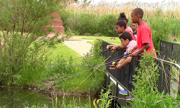
River Park is located at the convergence of the Chicago River and canal and offers a rich wildlife habitat, excellent fishing and a canoe launch. It has a swimming pool and an interactive water playground in the summer months.
The artificial turf soccer field and running track, as well as a soft-surface playground, draw visitors from around the city. The park also features seven tennis courts and two baseball fields.
2.Dam and Waterfall: Cross the river to the west side of the park and walk north to where the river splits. You will find the only dam and waterfall in the city of the Chicago. You will see what appears to be an abandoned little path in the bushes that line the river where it turns west after the dam. It is short, but interesting.
After you’ve explored the park, meander over to Lawrence and Sacramento to
3.Global Gardens, 2954 W. Lawrence: This empty lot was transformed into a vibrant farm where over 100 refugee families grow vegetables. This provides refugees access to fresh vegetables as well as reconnects displaced farmers with soil and food production. They also sell their vegetables at the Horner Park Farmers Market nearby. Visitors are welcome, so walk right in and look around. In addition to seeing thriving and abundant vegetable plots, you will notice gardeners of every race and nationality. You can enter through the main entrance on Sacramento, walk through and exit at a gate in the middle of the garden on Lawrence.
4.Ravenswood Manor: Ravenswood Manor is on the National Register of Historic Places because 96% of its buildings were constructed between 1909 and 1933 and are intact today. Ravenswood Manor represents architectural trends and urban residential neighborhood development in Chicago in the early 20th century. Chicago Bungalows and American Foursquares sit alongside high end architect designed, historic revival style residences. What also makes it so charming is its location along the river. Early brochures touted it as a “Motor Boat Colony” complete with a club house for the perpetual use of its residents. Resources for a more in depth look at this area are listed in Option 2.
5.Francisco Brown Line Station, 4648 N. Francisco : This station was built in 1907 and became the impetus for the development of Ravenswood Manor. It is all original except for its doors which needed to be widened to comply with ADA requirements. Ellen Harvey’s “Carpet” mosaic of hand cut marble on the ramp in and out of the station looks like an oriental carpet and it is a beautiful and welcoming transition into the community. The tracks are on grade and the station feels like a train stop in a small community. This is further enhanced by all the cute coffee and sandwich shops that sit right next to the station and patronized by commuters, residents and families.
Make your way back to Lawrence just west of the river. Cross Lawrence and enter Ronan Park. Take the wood chip path along the river and head north.
6.Ronan Park Restored in 2002, the Ronan Park includes 3 acres of naturalized river edge habitat along the North Branch of the Chicago River. A wood chip path in the park parallels the river, making Ronan Park a perfect spot for bird watching or a nature walk.
Across the river near Lawrence, you will notice a large, elegant, Art Deco building you might mistake for a fieldhouse. It is actually the North Branch Pumping station, a sewage pumping station built in 1929.
Ronan Park honors Ensign George Ronan, who died in the Fort Dearborn Massacre on August 15, 1812, when Potawatomi warriors routed the Federal forces at Chicago. Ronan was the first West Point graduate to fall in battle.
Optional Excursions:
1.North Park University, 3225 W. Foster: North Park University’s roots reach back to a Minneapolis church basement in 1891, where classes in language, and business gave Swedish immigrants the education and skills they needed to prosper in America. With an offer of land in Chicago, the school moved to the North Park neighborhood just beyond the city limits.
Old Main, the first building on campus, was completed in 1894. The Georgian Revival structure housed all departments of the school, from classrooms, library, and faculty offices to sleeping quarters, gymnasium, and dining room. In the Twenties, pilots used the cupola atop Old Main as a landmark by which to locate Orchard Field (now O’Hare International Airport). The cupola was the tallest point on the city’s north side.
From the beginning, North Park has expanded and adapted its educational mission to the times. At various points in its history, North Park was an academy, junior college, and four-year liberal arts college. They became a university, with a theological seminary, in 1997.
Campus facilities have been extensively renovated, including the LEED-certified Johnson Center for Science and Community Life, opened in 2014; the 2006 addition of the Helwig Recreation Center; the 2004 construction of the Holmgren Athletic Complex for football, softball, and baseball; and the 2001 construction of the Brandel Library.
We enjoyed walking this pretty and well maintained campus.
3.Cambodian Association 2831 W. Lawrence: A walk through the museum and memorial is very moving as the story of the Civil War in Cambodia, especially the Khmer Rouge Regime of 1975 – 1979, is told through multimedia displays, archives, narratives and artifacts.
Noble Seymour Crippen House, the oldest existing home in Chicago
How we got there: We drove. There is abundant, free street parking. You can check other public transportation options with the CTA Trip Planner.
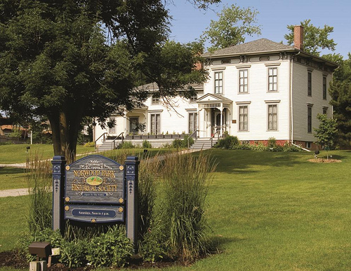
Marge’s comments: What a delightful walk this was! Most notable is the historic district which contains houses from 1880 – 1940. The homes are laid out on curving streets with nice setbacks. Parks and green space are sprinkled all over the district. The trees are huge and I imagine it would be the perfect walk to take when the autumn colors peak. This is a walk for peaceful meandering and chatting with the neighbors who were outside everywhere on the day we were there. We ran across them sitting on their porches, doing yard work, walking the dog or hustling children to and from activities. We even came across a block party where we were welcomed and offered a beer! Make sure to stop in the Norwood Park Historical Society where a docent will give you a tour of the Noble Seymour Crippen House (in which it is housed) and tell you the history of Norwood Park and some of its residents.
Ed’s Comments:
When you are driving on the Kennedy Expressway, did you ever wonder what lies just over the retaining wall? This idyllic neighborhood with curving streets, parks everywhere, and free range children would be the farthest thing from your mind. It is rich in history and yet is quite livable today. A jewel hiding in plain sight.
In 1833 Mark Noble filed claim to 150 acres of land in the area. He built a frame house on a glacial ridge and lived the life of a gentleman farmer. Today his home, at 5634 North Newark Avenue, is the oldest building in Chicago and home to the Norwood Park Historical Society.
Other farmers followed Noble. Then in 1868, a group of Chicago investors purchased 860 acres near the railroad for real estate development. Taking their name from a popular novel (Norwood by Henry Ward Beecher, the brother of Harriet Beecher Stowe), they called their community Norwood Park.
The new town featured wide lots with expansive front lawns. Instead of following the rigid Chicago grid, the streets were pleasantly curved–one of them even formed a circle. Three small parks were laid out and hundreds of shade trees planted.
To promote development, frequent ads were run in the Chicago newspapers. It’s worth quoting one of them:
“Only 11 miles from the Court House on the Chicago & Northwestern, 30 minutes ride. Eighty feet above the lake on beautiful, rolling ground, perfect drainage. No malaria, no saloons, no nuisances of any kind. Good society, churches, graded schools, stores.”
New settlers arrived. They built large Victorian homes on the high ground near the ridge. As Norwood Park grew, the residents saw the need for city services. In 1893, they voted to become part of Chicago. Today the historic heart of the original town is called Old Norwood. (from Norwood Park, Past and Present, WBEZ Blog, by John R. Schmidt)
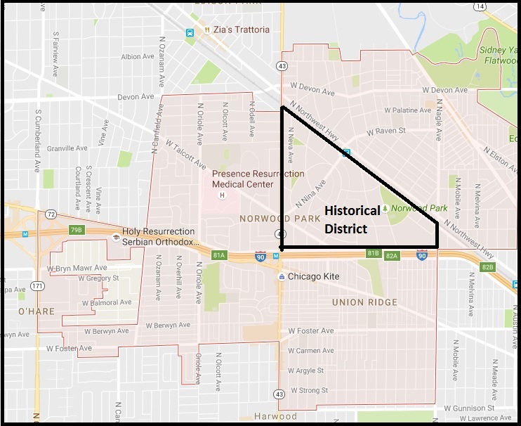
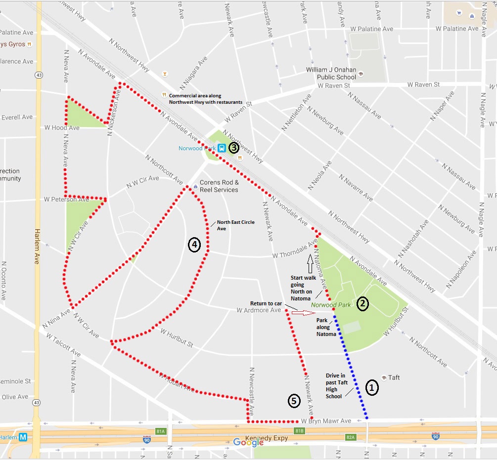
This walk encompasses only the “Old Norwood” neighborhood of Norwood Park.
1.Taft High School 6530 W. Bryn Mawr
Jim Jacobs, the writer of the musical, Grease, based it on his experiences as a student here.
2. Norwood Park 5801 N. Natoma Ave.
The Norwood Park District purchased 14 acres for its first park in 1921. Site drainage began in 1922, and bath house and swimming pool construction shortly thereafter. In 1928, the park district added a fieldhouse with a 500-seat assembly hall.
3. Norwood Park Train Station 6088 N. NW Hwy
The tracks were built in the 1850s and the current train station was built in 1907 and designed in the Prairie style by architects Frost and Granger. It is on the Register of National Historic Places. You can see it across the tracks as you walk along Avondale. Before the roads were paved, the only way you could get from Chicago to Norwood Park was the train. The roads were often impassable. The job of the sole Norwood Park Police Officer was easy. He parked himself at the train station and watched everyone getting off the train. If he didn’t know you or you couldn’t justify why you were there, he sent you back on the train!
4. North West Circle Avenue and North East Circle Avenue
The residential section of Old Norwood Park was designed to the “Picturesque Ideal”, holding that neighborhoods should be designed to imitate patterns found in nature. The curved streets of Norwood Park stand in sharp contrast to the gridiron plan of Chicago. The streetscape provides focal points in the neighborhood and helps define the community as distinct from its surroundings. Norwood Park was designed to create an image of nature and parks and vistas.
Although most streets in the district feature historic homes, large trees and curving roads, the Circle Avenues are unique for their size and presence. It is believed that informal horse racing took place around the circle in the old times followed by car racing after the circle was paved. The Circle Avenues were the first streets to be paved in Norwood Park.
5. Noble-Seymour-Crippen House, home of the Norwood Park Historical Society 5622-24 N. Newark Ave.
The House is listed on the National Register of Historic Places and is the oldest existing house in Chicago. It is named after its first three owners. After Mark Noble’s time, Seymour and Crippen added to the original humble structure. (Noble Square in West Town is named after Mark Noble’s two sons.)
When we popped in, a docent was on duty and gave us a tour of the house which acts as a museum for the historical society. The docent will tell you about the history of the house, the area and some of its residents. The museum collection has old photographs, letters and artifacts found in the area. They even have a hollowed out log which served as a water main back in its day. This is a worthwhile stop!
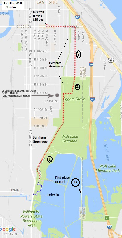
Length of Walk: The walking part takes you through the community area of East Side and totals 3 miles.
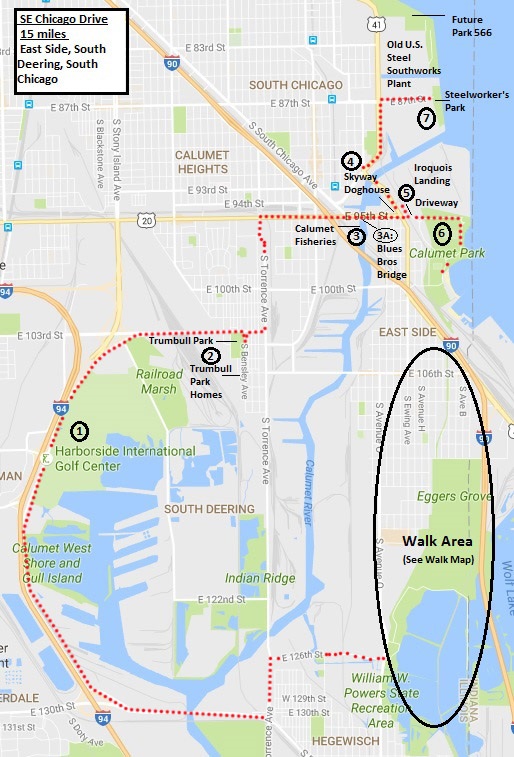
We’ve added a 15 mile drive of other highlights in the area with an emphasis on its industrial activity, past and present. This drive takes you through East Side, South Deering and the south end of South Chicago.
How we got there: We drove, entered the Powers State Recreation Area, parked and started our walk of East Side. After our walk, we took the #30 bus back to Powers. We got our car, then drove the 15 miles add on route of more East Side, South Deering and South Chicago. You can check other public transportation options with the CTA Trip Planner.
William Powers State Park
Marge’s Comments:
This area fascinates me.
As a child, I remember driving through this area on family trips, awestruck at the sight of the gargantuan steel mills and their belching, smelly smokestacks. It was unthinkable they could ever disappear.
To visit this area today is equally awe inspiring in its transformation. Remnants of industry still remain, but green space, parks, family homes, and big aspirations for development are now the focus of the area.
Our walk will focus on life in the East Side community and our drive will highlight the area’s industry, past and present.
Old U.S. Steel South Works site awaiting redevelopment
We were lucky to have personal tour guides for this walk!
Bobby Loncar, a lifelong resident and attorney, reached out to me after seeing our blog. He generously offered to give us a tour of East Side and is an energetic promoter of his community and its many attributes. He asked Christopher Rodriguez, a fellow lifelong resident, to join us for his perspective.
Bobby’s father emigrated here as a young boy from Croatia in 1968 and his mother emigrated here from Germany in 1980. He was born and raised in this neighborhood and is married, raising his own three children with his wife, a fellow long time resident of the community. Many of their relatives still live here, often just blocks away from them.
Christopher was raised in a Mexican and Irish household and is also a South sider for life. Even though he commutes 1.5 hours one way to his job up north, he cannot imagine living anywhere else. He has deep roots in the community and nowhere else would seem like home.
Both Bobby and Christopher lament that even though East Side has a lakefront park, forest preserve, state recreation area, abundant retail, affordable housing, reasonable real estate taxes, proximity to downtown (13 miles away) and a small town feel, the area does not get attention from potential residents and is overlooked as a residential choice. They work tirelessly to bring attention to these attributes and hope the day comes when their neighborhood gets “discovered’ by families and others looking for such qualities.
East Side House
Ed’s Comments:
What is so unusual about East Side is that it is a small town hidden within Chicago. With a population of 23,000, many people know each other. Kids play safely and the modest homes are well kept. This community borders Indiana and is one minute from the Skyway and the casino.
Real estate taxes are some of the lowest I have seen anywhere in the state, including my depressed hometown of Decatur. There is a window of time when people will realize that this community is affordable, comfortable and easy to drive to with plenty of parks and outdoors. When the window closes, it might very well get gentrified. A very pleasant walk any time of the year.
East side is one of the 77 official community areas of Chicago. It is located between the Calumet River and Indiana state line, just south of 95th St.
East Side, until recently, was socially and economically dominated by the Calumet River and the jobs it supported. The community got its name from the river because it was located on its east bank. The river formed the once-thriving industrial Port of Chicago. A cluster of riverside docks and slips allowed materials of all sorts to be loaded and unloaded onto adjacent railroad lines, and the river itself was lined with steel mills. Republic Steel began operations here in 1901. The Republic mill was the site of frequent union unrest, culminating in the Memorial Day Massacre of 1937 and the successful drive by the United Steel Workers to organize the Chicago mills.
Many of the neighborhood’s residents during this period were families of Slovenia, Croatian and Serbian heritage, who had emigrated from Europe to work in the steel mills and take related jobs. In the 1950s, the East Side was divided in two by the Chicago Skyway. The riverside steel mills and heavy industries went into serious decline in 1970-2000, and are no longer the mainstay of the neighborhood.
Currently, there are proposed plans to expand East Side’s Calumet Park and Beach, and to extend the existing lakefront bicycle path to the proposed new lakefront parklands in adjacent South Chicago. This proposed future expansion of Chicago’s southern lakefront parklands will result in the connection of Calumet Park to Rainbow Beach, the South Shore Cultural Center, and Jackson Park.
From Wikipedia
Today, the area is largely Hispanic and residents work primarily as city workers, white collar or in non-production jobs.
Start your walk of East Side by pulling into William W. Powers State Recreation Area entrance at 126th and Avenue O, turn left once inside, and find a parking space close to access to the Burnham Greenway. Map Points:
William Powers State Recreation Area
This is the only state park within Chicago. This park consists of 580 acres of which 419 are water. It encompasses Wolf Lake which provides outstanding fishing. It straddles the Illinois and Indiana state line. If you fish off the peninsula marked by 1A on the map and plan to fish on both sides of the bridge, you will need an Illinois and Indiana fishing license. Otherwise you can buy one license and fish only on that side of the bridge!
Once you’ve had your fill of the park, head to the westernmost part of the park and pick up the Burnham Greenway. The trailhead is on the left about 0.5 miles ahead along the park road.
Eggers Grove
The Burnham Greenway cuts through the western side of the forest preserve, but the day we walked was so beastly hot, we cut over into the forest preserve over a little boardwalk about half way into the preserve (at 114th St.). It was shadier and provided needed relief from the sun. We emerged in front of an open area with the Eggers Grove Comfort station, built in the 1930s, which was locked (and undergoing restoration?), but there is a water fountain and port-a-potty. The preserve is part of the Cook County Forest Preserve System and Eggers Grove touts itself as, “Right along the Illinois-Indiana border, 241 acre Eggers Grove is a rich, wet woodland, perfect for a picnic and games followed by a spring walk to see wildflowers and birds.”
From the Comfort Station, walk across the open field north to 112th St. Cross 112th to Avenue C
Residences along Avenue C
Stroll along the neat and well-kept residences along Avenue C to get a feel of how people live in the neighborhood.
When you get to 106th Street, make a left (west) and walk through some area retail. There are many ice cream shops to enjoy! When you get to Ewing Ave., you can wait for the #30 bus on the northwest corner. There is more retail up and down Ewing Ave if you want to browse before the bus comes. Catch the bus and head back to the Powers Recreation Area to pick up your car.
The Southeast Chicago Drive to other Points of Interest
Leave the Powers Recreation Area and head to 130th street. Right before Route 94, you will see an exit on your right for S. Doty Ave. Take it and follow it to:
Harborside International Golf Center
11001 South Doty Avenue East
The Port of Chicago consists of three facilities in this area: Iroquois Landing for ship cargo, Dougherty Harbor (terminals and harbor operations on Lake Calumet) and Harborside International Golf Center. There must be a story about how a Golf Center ended up in this industrial area run by the Port Authority, but I don’t know it! You can’t get into the Harbor operations, but as you make your way to the golf center, you will see glimpses through fencing. Once you get to the Golf Center, walk out to the back deck to view the golf courses as well as an expansive view of Lake Calumet and its terminals.
The Port of Chicago is run by the Illinois International Port District and under fire for underperforming in its management of this strategic asset. The City of Chicago has called for privatization and the Civic Federation has called for the dissolution and restructuring of the District, arguing that the District has no strategic vision or accountability.
Trumbull Park Homes and Trumbull Park
106th and S. Bensley Ave.
The last of three Public Works Administration projects commissioned in Chicago as part of Franklin Roosevelt’s New Deal, Trumbull Park Homes is arguably one of the CHA’s most historically significant buildings in its housing portfolio. Built in 1938, the development features a low-density design of two-story rowhouses and three-story apartment buildings spread out across 21-acres. Turmoil erupted in 1953, when the first Black families moved into Trumbull. Daily outbursts of rioting broke out and continued for more than seven months. From 1953 to 1957, sporadic acts of violence, including aerial bombs, riots and arrests, accompanied the move-in of black families. The subject made a 1954 issue of Time Magazine and spurred a march on city hall by the Chicago Negro Chamber of Commerce. – from the Chicago Housing Authority website
Trumbull Park (2400 E 105th St.) is located next door and features a classically-designed Beaux Arts fieldhouse built in 1914, as well as a magnificent stand of gingko trees in its central plaza. It is also listed on the National Register of Historic Places.
3. Calumet Fisheries, 3259 E 95th St.
This famous fishery is known for smoking their own fish on site.
3A. Blues Brothers Bridge 95th St. Bridge at Calumet River (US-12), Chicago IL
This is the scene of the famous “jump” over the drawbridge in The Blues Brothers movie.
Skyway Doghouse 9480 S Ewing Ave
Another famous eatery whose specialty is hot dogs.
Iroquois Landing
This is part of the Port of Chicago and one of the largest stevedoring (cargo loading and unloading off ships) sites in North America. You can’t get in here, but if you pull in the driveway on your left (north) off 95th street just after crossing Ewing and drive up to the gate you will get a glimpse through the fence of the massive cargo yard. Who knew this was here??? It has the same impact in its gargantuan presence as the steel mills once did!
Calumet Park 9801 S. Avenue G
This park is where it is happening in SE Chicago!! We’ve walked this park twice and it has been jam packed with activity both times. On the day we took the walk through East Side, it was so hot and humid that Powers Park and Eggers Grove had almost no visitors. Once we arrived in Calumet Park, we could barely drive. There were people everywhere. And for good reason. This lakeside park of 200 acres offers a beach, boat launch, softball, football, and soccer fields, picnic groves, playgrounds and a fieldhouse with extensive programs. As mentioned earlier, the proposed future expansion of Chicago’s southern lakefront parklands will result in the connection of Calumet Park to Rainbow Beach, the South Shore Cultural Center, and Jackson Park.
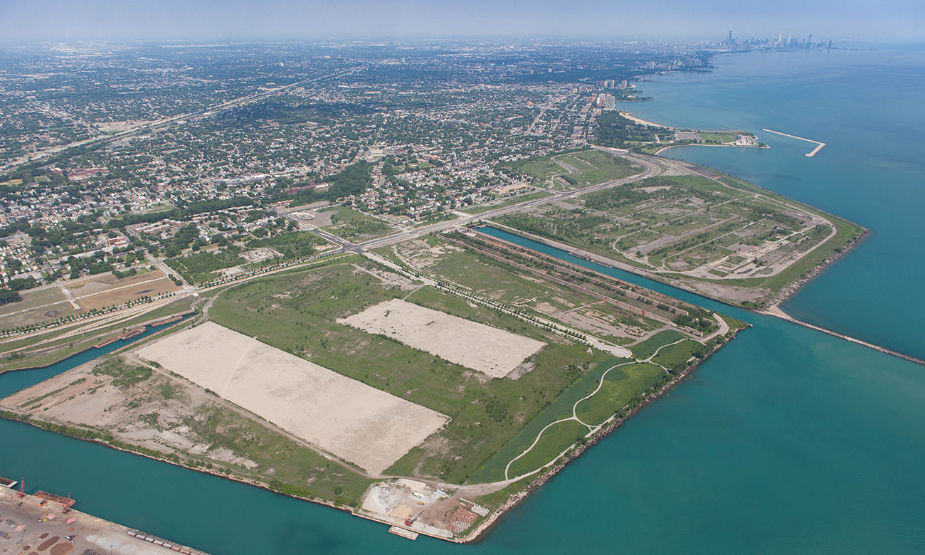
Old U.S. Steel Southworks Steel Mill site
430 lakefront acres between 79th street and the Calumet River
Though a few remnants like old stone walls and tunnels remain on this property, the steel mill has been completely dismantled. Steelworkers Park exists on the east side of the southern portion and Park 566 is planned for the east side of the northern portion. A mega development project between U.S. Steel and McCaffery Interests slated for the balance of the 430 acres officially died this year after 12 years of planning.
U.S. Steel is now selling the property outright. DNA Info reports that, “The project is being rebranded as 8080 Lakeshore and Cushman and Wakefield have come in as the brokers. The group is marketing the land as close to Hyde Park and the future Barack Obama presidential library and the historic Pullman neighborhood, and are casting a wide net in search of industrial, research, entertainment, residential and mixed use projects.
The new division of the land creates three properties east of the Lake Shore Drive extension ranging in size from 56 to 135 acres. A fourth parcel west of Lake Shore Drive is 111 acres and is closer to neighboring South Chicago, but has no access to the three miles of lakeshore on the site.”
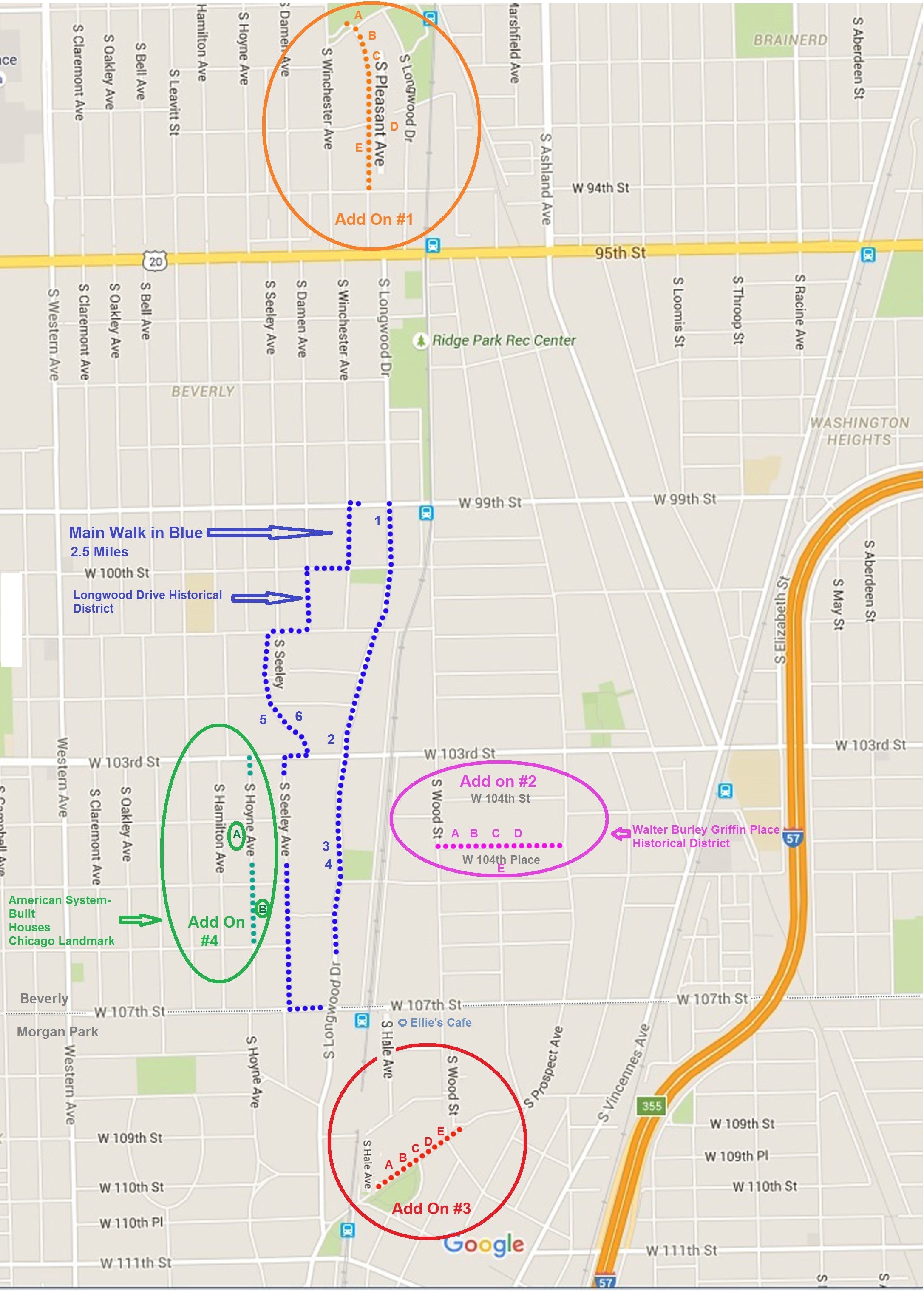
Length of Walk: The main walk is 2.5 miles. There are 4 “Add Ons” you can add to the main walk which are about one block each. If you string them all together into one route you will walk about 7 miles. Alternately, you could drive to each “Add On” of interest and walk the individual block.
Where it is located: This walk will take you through the community areas of Beverly and Morgan Park. It is Walk #8 on the Walk Locations Map.
The Irish Castle in Beverly
How we got there: We drove and parked on the street. There is free and plentiful street parking everywhere along this route. Metra has five train stops within a couple of blocks of the walk. You can check your options with the CTA Trip Planner.
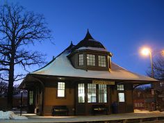
99th Street Beverly Metra Station
Marge’s Comments: Take this walk on a beautiful summer day when Beverly is at its best. Lush landscaping and beautiful homes on the ridge make you want to pack your bags and move here. The residents take pride in the rich history of the community which you will notice by all the historical plaques displayed prominently in the front yards. This was the hardest walk to edit and I hope you will use the resources below to read up on the area and add even more stops to your excursion. There is a cute little neighborhood cafe in the middle of your walk: Ellie’s Cafe. Stop here and enjoy watching the locals coming, going and socializing.
Griffin Prairie Style House DNA Info Howard Ludwig
Ed’s Comments: Many Chicagoans feel that the south side is scary and alien, a foreign place where the higher the street number the more dangerous. Two steps into this enchanting neighborhood and you will realize how foolish this notion is. Beverly competes with all the top suburbs for beauty, stateliness, and significance. The drive out there takes a few minutes but the train ride is a breeze from the loop. It is well worth the effort.
Like many of the community areas of Chicago, Beverly and Morgan Park developed in the late 1800s when rail service was extended to the area. Prior to European American settlement, the area was home to the Potawatomi Indians.
The natural beauty of its position on the ridge allowed the community to become an exclusive streetcar suburb, and the homes and large lots reflect this historic distinction. Beverly is located on the highest elevation in Chicago and is one of the most racially and diverse neighborhoods in the city. It is home to a large Irish-American/Catholic community and many Irish establishments. Its yearly South Side Irish Parade is the largest neighborhood parade of any type in the country.
The hilly terrain of the area is due to its location in the middle of the geological formation known as the Blue Island Ridge. In its early years, Beverly and Morgan Park were known as North Blue Island.
Beverly is one of the top five largest historic districts in any major city in the U.S.
–from Wikipedia
Because there is so much to see in this area and walking a continuous route among all them would total about 7 miles, I developed a base walk in the heart of the Longwood Historic District of 2.5 miles and itemized other “Add On” walks which you can add to your walk or drive to and walk the block listed.
Main Walk (From Ridge Historic District National Register of Historic Places Inventory Nomination Form and Chicago Landmarks )
The Chicago Designated Landmark of the Longwood Drive District: Unique in the city for its hilly topography, this narrow, 12 block long district is dominated by a natural ridgeline. Because it stood 50-80 feet above Lake Michigan and was often covered by a blue mist, the ridge was commonly referred to by early settlers as “blue island.” This community began as several separate suburban developments, which were annexed to Chicago around 1900. A rich mixture of architectural styles characterizes this district, ranging from the Italianate and Carpenter Gothics of the 1870s, to Queen Anne and Shingle (1880s and 90s) to Prairie School and Renaissance Revival (early 20th century)
1.) 9914 S. Longwood
Built in 1909 by architect Frank Lloyd Wright
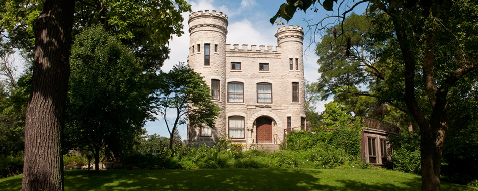
2.) 10244 S. Longwood Irish Castle
Built in 1886 for $ 80,000 by developer Robert C. Givins
The castle of native Joliet limestone is a replica of a castle on the River Dee in Ireland. It has been occupied by the Unitarian Church since the early 1940’s
3.) 10400 S. Longwood Anderson House
The house was owned for many years by John S. McKinlay, president of Marshall Field and Co. It is now the official residence of the president of Chicago State University.
4.) 10432 S. Longwood
Home of S.E. Thomason, a noted newspaperman and co-founder in 1928 of the Daily Times, Chicago’s first tabloid newspaper.
5.)10224 S. Seeley Le Bosquet House
One of several architecturally significant homes on Seeley
6.) 10235 S. Seeley
One of several architecturally significant homes on Seeley
Add On #1 (From Ridge Historic District National Register of Historic Places Inventory Nomination Form)
What is here: Really old, historic and architecturally interesting homes in a secluded, pleasant neighborhood
A.) 91st at Pleasant Vincennes Trail
A boulder and bronze marker were placed in 1928 at the point where the Vincennes Trail descended the ridge approaching Fort Dearborn. The Trail, originally a major Indian trail, was one of the most important roads leading into Chicago and played a substantial role in the city’s early development.
B.) 9167 S. Pleasant Henry Belding House Built 1893
Henry Belding was a prominent manufacturer connected with the soap company of the same name. This also marks the site of the “Upwood” farm of Thomas Morgan, one of the area’s original settlers. Stones from the farm’s sheepcote were used in constructing the present home.
C.) 9203 S. Pleasant M.R. French House
W.M.R. French was prominent in artistic circles in the city and one of the first directors of the Chicago Art Institute. A frieze on the porch is by his brother, David-Chester French, designer of the Washington Monument.
D.) 9319 S. Pleasant
From 1897 until 1910, the home of John H. Vanderpoel (1857-1911), a noted painter and teacher. Vanderpoel was head of the instruction department at the Art Institute of Chicago, author of the standard instructional work The Human Figure, and a member of the British Royal Academy. A street, school, and public art museum in the district are named in his honor.
E.) 9326 S. Pleasant Jessie M. Adams House
Built in 1900 by architect Frank Lloyd Wright
Add on #2: Walter Burley Griffin Place District (from Chicago Landmarks and Ridge Historic District National Register of Historic Place Inventory Nomination Form)
The largest concentration of small-scale, Prairie-style houses in Chicago. Seven of these residences were designed by Walter Burley Griffin, an architect who began his career with Frank Lloyd Wright. An eighth Prairie-style house was designed by Spencer and Powers. So-called “builders’ houses,” which were constructed by contractors from plans popularized in building magazines of the same period, complete the street.
A.) 1736 W. 104th Place Walter D. Salmon House
Built in 1912-13 for Samuel J. Wells by architect Walter Burley Griffin. Wells was R.L. Blount’s (builder of the Griffin Houses in this district) father-in-law. Salmon rented the house until purchasing in 1917.
B.) 1724 W. 104th Place Russell L. Blount House I
Built in 1910-11 for R. L. Blount by architect Walter Burley Griffin
Blount worked in real estate for the Continental Bank and also built and sold homes on his own. He was responsible for all but one of the extant Griffin houses in the district.
C.) 1712 W. 104th Place Edmund C. Garrity House
Built in 1909-10 for R.L. Blount by architect Walter Burley Grifffin
Blount originally intended the house as his own residence but sold it before completion to Garrity, president of the National Plumbing and Heating Co.
D.) 1666 W. 104th Place Harry G. Van Nostrand House
Built in 1911 for R. L. Blount to plans by architect Walter Burley Griffin.
Van Nostrand was a salesman who rented the house before purchasing it in 1916.
E.) 1727 W. 104th Place Arthur G. Jenjinson House
Built in 1912 for R. L. Blount to plans by architect Walter Burley Griffin
Add On # 3:(From Ridge Historic District National Register of Historic Places Inventory Nomination Form)
What is here: These old historic homes are in Morgan Park and this stop gives you a little feel for Morgan Park and its history.
A.) 10956 S. Prospect Thomas Lackore House
Built in 1870-72; much altered
Thomas Lackore was a relative of the area’s first permanent settler, DeWitt Lane, and scion of the Lackore family prominent in the early settlement of the ridge.
B.) 10934 S. Prospect W. Ferguson House
Built ca. 1871
Ferguson was president of the Lancaster Insurance Company. The second owner, Henry Crosman, was a prominent Chicago industrialist and one of the founders of the Chicago Opera Co.
C.) 10924 S. Prospect William H. German House
Built in 1884; since extensively remodeled
Dr. German was the first physician in Morgan Park and one of the village’s most prominent citizens.
D.) 10910 S. Prospect Ingersoll (I.S. Blackwelder) House
Built in 1866; extensive additions in 1877
Blackwelder was president of the Niagara Insurance Company, which adjusted many losses from the Great Fire of 1871, and president of the village of Morgan Park. His wife was very active in local affairs and was the first woman to vote in an election in Cook County.
E.) 10900 S. Prospect S. Dickey House
Built in 1912 by architects Chatten and Hammond
The house is sited on a four acre lot, largest in the historic district and one of the largest residential lots in the city.
Add On # 4: From Chicago Landmarks
American System Built Houses: Based on his long term interest in affordable housing, influential architect Frank Lloyd Wright developed a series of prefabricated housing designs marketed under the name “American System Built Houses.” The building at A. 10410 S. Hoyne was erected by Burhans-Ellinwood & Co. as the model home for a subdivision to be comprised of these residences (1917). The only other Wright designed house to be built, before the project was abandoned at the outset of WWI, is at B. 10541 S. Hoyne (1917). It was built for H. Howard Hyde, a cashier at International Harvester.
It is believed that about 25 System-Built Homes were constructed, but only 15 survive. New ones are discovered occasionally, not surprising when you consider Wright and his partner had a falling out over fees and commissions and Wright’s plans could have been used and undocumented to avoid paying him his fees. They can be found in Wisconsin, Illinois, Indiana and Iowa.
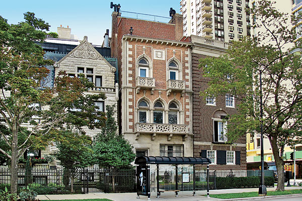
Where it is located: These walks take you through the Gold Coast neighborhood of the Near North Community Area of Chicago. It is Walk #7 on the Walk Locations Map.
Cardinal’s Mansion
How we got there: There is limited parking in this neighborhood and it is expensive. Check Spot Hero or look for parking lots on Google Maps if you are determined to drive. The area is well served by public transportation and taxis are abundant.
Marge’s Comments:
This area is one of the most beautiful in the city. Historical mansions line leafy, quiet streets, yet it is a quick walk to many restaurants and exclusive shopping. It is no wonder the city’s wealthiest residents call this area home. There are many options for touring this neighborhood. The Chicago Architectural Foundation conducts walking tours here as well as several other companies. Rather than reinvent the wheel, I list links to two options below for self guided walking tours; one from Frommer’s and the other by MetrowalkZ.
Ed’s Comments:
Tourists from all over the world throng to this popular and storied neighborhood. A short walk from Michigan Avenue with restaurants galore, what better way to spend a free morning or afternoon. The highest property values in the city insure that these mansions and town homes are distinctive and in mint condition.
The Walk:
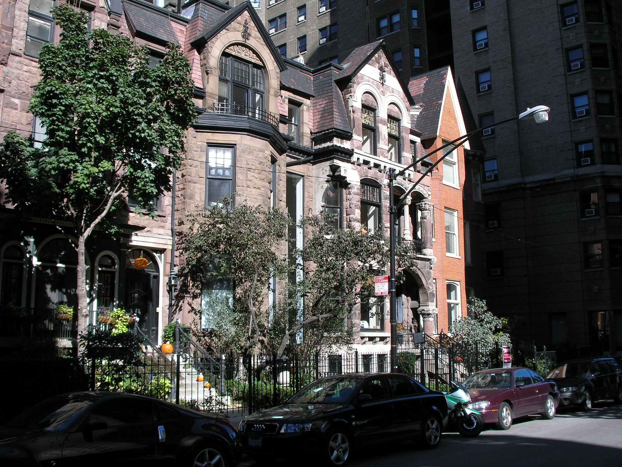
Gold Coast
The Gold Coast neighborhood grew in the wake of the Great Chicago Fire. In 1882, millionaire Potter Palmer moved to the area from the Prairie Avenue neighborhood on the city’s south side. Other wealthy Chicagoans followed Potter into the neighborhood, which became one of the richest in Chicago. In the late 1980s, the Gold Coast and neighboring Streeterville comprised the second most-affluent neighborhood in the United States, behind Manhattan’s Upper East Side. Today, the neighborhood is a mixture of mansions, row houses, and high rise apartments. Highlights include the Astor Street District and the James Charnley House.
The Astor Street District forms the core of most walking tours. Constructed over a period of more than 100 years, the buildings along Astor Street reflect the fashionable styles favored by their original high-society residents. The numerous 19th-century houses are designed in a variety of historical revival styles, and are interspersed with apartment buildings and townhouses. It was designated a Chicago Landmark in 1975. Interestingly, Astor Street was named after John Jacob Astor who never lived in Chicago. Because he was one of the richest citizens in the United States in the mid 1800s, his name gave a luster to the area. (From Wikipedia)
Where it is located: This walk is in the South Shore Community Area of Chicago. It is Walk #6 on the Walk Locations Map
South Shore Cultural Center Gate by wikimedia
How we got there: We drove and parked in the Jackson Park Highlands where there is plenty of street parking. If you drive, try parking on S. Cregier Ave., where the walk begins. You can review your public transportation options at: CTA Trip Planner
Marge’s Comments:
This walk is delightful for a late summer afternoon. Walk through the peaceful historic district of Jackson Park Highlands taking in every residential style imaginable from the early 20th century. End your day by driving over to the South Shore Cultural Center and walking through the grand restoration of this former country club, now owned and operated by the Chicago Park District. If the Parrot Cage Restaurant is open, you may be lucky enough to get a table outside with expansive views of Lake Michigan.
Ed’s Comments:
Just imagine that you have 80 acres of undeveloped land just south of the White City at the 1893 Columbian Exposition and decide to develop it for the elite. The result is the Jackson Park Highlands neighborhood. Today these few blocks are an oasis of stately well kept homes nestled into a changing and challenging neighborhood. You won’t believe this secret has been so well kept.
The first to populate South Shore were German truck farmers who raised vegetables on small farms for sale in what was then the distant city. When the area was annexed to the city in 1889, city services extended into South Shore, spurring residential development. The opening of the University of Chicago and the World’s Columbian Exposition in Jackson Park in the 1890s also had a huge impact on the entire South Side Lakefront. The 1890s and early 1900s saw South Shore’s evolution into a full-fledged middle and upper middle class neighborhood. The 1906 founding of the South Shore Country Club established a popular social anchor for the area and contributed additional cachet to the South Shore community.
The Jackson Park Highlands came into being on August 3, 1905 as an eighty acre subdivision whose initial development was spearheaded by Chicago alderman, lawyer and real estate entrepreneur, Frank Bennett. The majority of houses, built between 1905 and 1940, reflect the rich and diverse forms and fashions of American residential architecture for 20th century single-family homes before WWII.
The Jackson Park Highlands is notable for its well preserved residential architecture for a formative time in American Residential Architecture. At the turn of the century, architects tended to follow one of two courses, either reviving styles of the past or working in styles that were innovative and progressive. Revivalist architecture reached its height of architectural excellence during the first 29 years of the 20th century, when Beaux Arts schooling provided traditionally trained architects of great skill, and the stock market had not yet eliminated most of their clients.
As you walk up and down the streets, you will see New England, Southern, Spanish and Dutch Colonial, English Tudor, Cotswold Cottage, French Provincial, Mediterranean Villa, Foursquare, and newcomers like Prairie and International styles. Many have matching two story “auto sheds” down their driveways. (From the Preliminary Staff Summary on the Jackson Park Highlands District submitted to the Commission on Chicago Landmarks, October 1988)
Do a quick drive by (red dotted line) of these two notable sites before starting the walking tour of the Jackson Park Highlands (where blue dotted line starts).
1. 7121 S. Paxton Av., Allan Miller House
1915 John Van Bergen, Architect
This house is notable as it is the only known work of Van Bergen left in Chicago. Van Bergen was a disciple of Frank Lloyd Wright and one of the most important contributors to the Prairie School of Architecture. Also notable in this house is the remarkable state of preservation. Probably no other Prairie School house in Chicago remains in as pristine condition as the Allan Miller house.
2. 2132 East 72nd Street, St. Philip Neri Church
1928 Joseph W. McCarthy, Architect
The church is a testament to the rapid growth of the South Shore neighborhood in the early years of the 20th century, when a dramatic growth in the population of German and Irish Catholics caused a rush of speculative building. Though the church may today appear decidedly traditional, at the time of its construction it was thought to be a great adaptation to its location and function and its style became known as “South Shore Gothic, 1928.”
Drive the route of the red dotted line and park your car near stop # 3 on S. Cregier where the blue line denotes the start of the walk. The numbered stops 3 – 8 are some notable homes in the Jackson Park Highlands. I just picked a couple from the Chicago Landmark Designation Report . You may want to research others from this report to add to your walk.
3. 6909 S. Cregier Ave., Cotswald Cottage
Phillip Maher, Architect
Phillip Maher incorporated the details of a picturesque English rural house type, the Cotswald Cottage, which is identified by its steeply sloping roof make of simulated thatch.
4. 6734 S. Bennett Avenue, Distinctive and featured on the 1922 cover of the Chicago Architectural Exhibition catalogue.
1917 Zimmerman, Saxe and Zimmerman, architects
While most houses were either traditionally academic or progressively modern, this house is an adroit amalgamation of stylistic references from both major trends. The long, low lines of this one story house, which mimic the flat horizontal lines of the Midwestern Landscape, are directly derivative from the Prairie school pioneered by Frank Lloyd Wright. The horizontal rows of windows, the massive masonry porch supports and the flattened pedestal urns are also Prairie style trademarks. From the California Craftsman style of Greene and Greene, which like the Prairie style was inspired by the Orient, come the multiple roof planes and peaked roof line of the two front gables. Turning to the past, the architects employ false Tudor half-timbering for a decorative effect, and a Renaissance classical balustrade bands the front terrace.
5. 6826 S. Euclid Ave, one of the first homes in the Highlands
1905 Greek Revival
This style has had a lasting attraction to Americans since the early days of the republic when it was promulgated in particular by Thomas Jefferson. With their democratic ideals and institutions, Americans felt themselves natural heirs to ancient Greek and Roman traditions as well as their architectural forms. The classic Greek Temple front is seen on court houses, capitol buildings as well as middle class houses.
6. 6801 S. Bennett Ave., Beaux-Arts Classicism
Phillip Maher, Architect
The style takes its name from the Ecole des Beaux-Arts in Paris, where some of America’s most prominent architects had studied. Its grandiose use of classical forms was employed to great popular success at the World’s Columbian Exposition in Chicago in 1893 and became an ideal medium to express corporate wealth or civic pride.
7. 6841 S. Bennett Ave.
1915, Harlev & Aga (from AIA Guide to Chicago)
Among the unusual features of this eclectic house are brickwork that imitates half-timbering and terra-cotta plaques (more commonly found on commercial buildings) stuck like postage stamps on the piers.
8. 6956 S. Bennett Ave., archetype of the International Style
1926, Paul Schweikher, Architect
Of all the early twentieth-century styles – Prairie, Craftsman, Art Deco – that deliberately rejected past history and sought to be timely and modern, the most radically iconoclastic was the International Style of the 1930s. Many of the world-class architects of European origin who also worked in the United States, among them Walter Gropius, Ludwig Mies van der Rohe, and Marcel Breuer, initiated their practices working in the International Style, generally characterized by a stark simplicity devoid of applied ornamentation. Ribbon windows were an important trait of this style as were corner windows in which the glass was mitered without any corner support. Other design features were flat roof tops and smooth, uniform wall surfaces.
Return to your car on S. Cregier Ave. and head over to the South Shore Cultural Center.
9. South Shore Cultural Center, 7059 S. South Shore Dr.
1906, 1919, 1916, Marshall and Fox, Architects
The South Shore Cultural Center was originally designed as a private club, the South Shore Country Club, by the architectural firm of Marshall and Fox. The architects renowned for their hotel and apartment building designs throughout the Chicagoland area, Marshall and Fox are best known for their design of the Drake and Blackstone Hotels. They constructed the original South Shore Club House in 1906 in the Italian Resort Style, resembling a summer palace. Of the original structure, the only remaining portion is the ballroom (now Paul Robeson Theatre) on the south end of the existing building. In 1916, after expansion in membership and social importance in Chicago, the old clubhouse was moved to the south section of the grounds and became the golf club house (no longer in existence). Marshall and Fox were hired again to design a new clubhouse.
For decades, the South Shore Country Club was a playground for Chicago’s rich. In the 1960’s, the club was abandoned and fell into disrepair. Over the next few years, community activists pushed to have the club restored and in 1974, the Chicago Park District purchased the club for $10 million. The site became listed on the National Register of Historic Places in 1975. In 1984, the Chicago Park District rehabilitated the club house using interior color schemes developed by the original architects, Marshall and Fox.
Today, the South Shore Cultural Center is one of the Chicago Park District’s most significant historical sites. The center sits on 58 acres of land and is a common space for weddings, banquets and cultural activities. President Barack Obama and First Lady Michelle Obama had their wedding reception here.
(From Hyde Park-Kenwood Community Conference Parks Committee)
The Parrot Cage Restaurant, run by the Washburne Culinary Institute, also is housed here.